Technical Paper Title: Automated 3D Building Reconstruction using LIDAR TECHNOLOGY
Authors: Ajinkya.k.Sawant & Hiral.P.Parekh, 3rd Year BTech, Electronics and Telecommunication Engineering
College: Vivekanand Educational Society’s Institute of Technology
Abstract:
This Research paper helps us to study the structure, position of the buildings and various climatic conditions & natural calamities affecting the structure in observation and necessary changes needed to avoid effects of climatic changes surrounding the structure.
Keywords: LIDAR, ALS, 3D Buildings, etc
1.Introduction:
This research mainly includes the idea of making new building models in place of existing old buildings so that the reconstructed model would be resistant to all the climatic conditions and will increase its sustainability to a great extent.
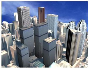
Figure 1: 3D model developed by using Lidar.
2. LIDAR (Light Detection & Ranging)
TECHNOLOGY:
Lidar (Light detection and ranging) is a Recent development in remote sensing with great potential for creating high resolution and accurate digital elevation models (DEMs). It has proven a mature state of art technology acquires a three-dimensional point cloud that describes the Earth’s surface. The standard features of recent airborne Lidar systems are their ability to discriminate between first and last pulse reflections. A laser pulse that is fired over an object usually has multiple reflections. While high-resolution imagery offers very detailed information on object attributes, such as spectral signature, texture, in this way, Lidar produces a fast and highly accurate three-dimensional surface. Combining these two kinds of complementary datasets is quite promising for building extraction, 3D city modeling etc. While the orientation and height of a roof face can be estimated accurately, the outline of a roof face is more difficult to determine. The building footprints provide the accurate location of outer edges .When building models are constructed with solid geometry, buildings can be regarded as compositions of a few components with simple roof shapes (such as flat roofs, gable roofs and hip roofs). The 2D corners of the building outlines often give an indication of the 3D position of these building components within the building footprint.
With the above views in mind, this paper describes the procedure for extracting building footprints and subsequent 3D building models by combining Lidar and high resolution imagery in an object-oriented perspective. The following section reviews the use of high resolution imagery and Lidar data in context of 3D building modeling. The third section describes the method and techniques and the fourth section discusses the main findings and advantages of the integrated approach.
The creation of a digital terrain model (DTM)/digital elevation model (DEM) can be performed in a number of ways. These include:
1.Direct measurement onsite using conventional
Surveying, including the global positioning
System (GPS)
2. Photogrammetric techniques,
3. IFSAR (InterFerometric Synthetic Aperture
Radar), and
Lidar (Light Detection and Ranging)
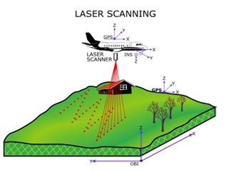
Development of a system comprised of a laser scanner, global positioning system (GPS), and an inertial measuring unit (IMU) that can meet map accuracy guidelines has been a relatively recent occurrence (see figure 2a). This is a technology at its infancy and rapid evolution in market.
Figure 2a: Lidar sensing system geometry
There are basically two types of laser scanning systems: pulsed laser and waveform. The pulsed laser system is the predominant form used for topographic mapping. A discrete signal is emitted from the laser and one or more return signals are recorded. Waveform systems use a Continuous signal
Different scan frequencies can be used by Lidar scan systems (see figure 2b). The selected frequency will depend on the application. Project requirements as well as Eye safety will determine the flight altitude. Typically this falls within a range of 100 to 5,000 meters at speed of 75 to 250 kilometers per hour.
Figure 2b: Aero Scan Lidar System.
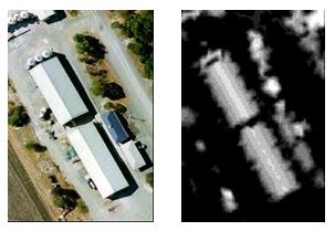
Figure : Photographic and Lidar data sets
(DSM) of the study area.
3 Creation of initial building model:
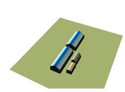
After extracting the height jump edge points with their planar faces, a bi-linear surface interpolation was applied to reconstruct initial building model. All detected roof faces of the buildings are shown in figure 8.
Figure . Reconstructed 3D building model.
In this case, these objects were manually selected and processed for further refinements. Thus, with the help of LIDAR technology accurate & detailed 3D models of the buildings were created with high fidelity 3D virtual environment modeling.
4. Advantages:
- Surveying accomplished Day or Night & in hard to reach locations e.g. – forest canopy.
- Accurate, less man power & High Fidelity Data extraction.
- Detailed modeling.
5. Conclusion:
Thus, from the above discussion we can say that in LiDAR we can get the exact model of the building without any assumptions in data to a great extent as needed in other extraction methods. By all indications, LiDAR appears to be a technology that will considerably change mapping in the future. This is the new technology whose current research is going on in IIT, MUMBAI and IIT, KANPUR in INDIA and in many other countries to great extent. The RESEARCH carried out in IIT MUMBAI showed that the results were quite accurate and feasible during our research on the topic. This technology has been studied and implemented in INDIA for studying the Mysteries of the historical monuments and for buildings which will be resistant to various natural calamities like Tsunami, MUMBAI Floods, Earthquakes; etc. which would bring about a great revolution in the Building Reconstruction Technology. Even the tallest construction in the world BURJ KHALIFA (Dubai) has been constructed by considering all environmental effects of surrounding areas by laser scanning technology.
6. Acknowledgements:
We would like to thank for co-operation of IIT Bombay Civil Dept professors for helping us understand Remote Sensing and its importance in today’s world.
7. References:
- Paper of 3D Building Reconstruction by Dr. Rottensteiner.
- Books -GIS Magazine and documents on 3D Building reconstruction by Stephen .Adams, 3D Modeling of Old Buildings by LIDAR TECHNOLOGY by F.Scholten.
The Above article is an edited version. Some parts of the article has been removed/edited based on the objections raised by Sudhagar Nagarajan, PhD and Dr. J. Mathivanan, PhD.


